Gary Ames caught the map bug 20 years ago.
At the time, the history buff had a second home in Santa Fe, New Mexico, and was intrigued by how few people knew that one of the oldest buildings in the U.S. is there, not in colonial America.
Ames found that many maps, some centuries old, included historic Santa Fe. The city’s Barrio de Analco is one of the oldest European-style neighborhoods in the U.S., dating back to the early 1600s, according to the National Park Service. The De Vargas Street House in that neighborhood is built on the foundation of a Native American pueblo from the 13th century.

Fascinated with what else the maps did and did not contain, Ames wondered how the mapmakers of the day knew what to draw of North America.
His fascination led to the acquisition of three dozen maps of Mexico and early North America. His work as CEO of MediaOne International demanded weekly intercontinental travel, which allowed him to scour old bookstores in Western and Eastern Europe. He searched and acquired maps for five years, turning a pastime into something of an obsession.
“I always liked history,” says Ames. “Finding certain maps became a fascination.” He soon discovered that in the mid-1990s, not many people in Eastern Europe were looking for maps of North America. Much to his delight, many maps of the “new world” were there for the picking.
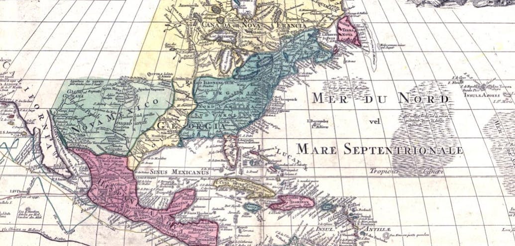
He learned that early cartographers, largely concentrated in Europe around Amsterdam, often worked off the notes of ship captains and explorers. It was not uncommon for details and meanings to get lost in translation. The resulting maps were often beautiful but full of errors, guesswork, and humorously hasty conclusions. One French map shows the imaginary Northwest Passage plainly marked, connecting the Pacific Ocean through the Arctic Ocean across North America. A map from the late 18th century shows California as an island.
As North America became an increasingly valuable prize for competing nations, sometimes critical geographic names were omitted from maps for military reasons. Should the maps fall into the wrong hands, sovereign interests could be compromised and lives lost.


Today, those maps, which once adorned the walls of the Ames home, comprise the Ames Map Collection in the Ames Library at Seattle Pacific University. Gary realized that when he and his wife, Barbara, moved their second home to California three years ago, there was no wall space for so many maps. “I wanted to keep the maps together,” says Gary, who is a former chair of SPU’s Board of Trustees. At the time, the SPU library building was being named the Ames Library for the couple’s significant service and contributions to the University. It made sense to the Ameses to donate the map collection for use by students and faculty members, and for display in their namesake library.
The maps, now hanging on the library’s walls, represent 500 years of evolution in exploration. The earliest of them contain blanks and false information, while later ones are more detailed and precise thanks to greater accuracy and evolving technique in the science of cartography.
University Librarian Michael Paulus views rare and historic maps such as those in the Ames Collection as windows into the process of scholarship and scholarly communication — how knowledge is communicated, corrected, and developed over centuries.
“They are rich primary sources,” says Paulus. “They are visual representations of how discovery happens over time.”